
Mines of the Foresthill Divide: Interactive Map Guide
Welcome to the Mines of the Foresthill Divide interactive map, a comprehensive resource for exploring the historic gold mines of California’s Foresthill Divide, a key region of the 19th-century Gold Rush. This guide explains the map’s purpose, how to use it, and important details about the data. Please read this introduction fully the first time. If you’re returning, jump straight to the map by clicking “View Map“.
Purpose of the Map
The Mines of the Foresthill Divide map is designed to showcase the region’s gold mines and provide detailed historical information about each one. Histories vary from brief summaries to in-depth accounts, depending on available records. This is an ongoing project, with new mines added and existing data updated regularly. To stay informed about updates, subscribe in the “Stay In The Loop” form at the top right of this page.
How to Use the Map
Once you click the “View Map” link from the main navigation bar at top, an interactive map will appear.
Follow these steps to explore:
- Zoom In: Click the plus sign to enlarge the map.
- Option 1 – Search by Mine Name:
- Locate the mine name in the left column.
- Click the name to zoom to the mine’s location on the map.
- Click the mine’s number on the map to view its history.
- After reading, click CLOSE to return to the map.
- Option 2 – Browse the Map:
- Hover over a mine icon to display its name.
- Click the icon to open the mine’s history.
- Click CLOSE to return to the map.
Key Information About the Foresthill Divide
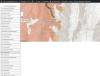
- Geology: The Divide is capped by volcanic andesite, shown as reddish-brown areas on the map. This capping varies from a few feet to hundreds of feet thick, and most mine tunnels begin beneath it.
- Historical Data: The map draws on a detailed 1885–1890 study by USGS Mining Engineer Ross E. Browne, whose 1890 Foresthill Divide map remains highly accurate, as confirmed by modern geologists.
- Boundaries: The Foresthill Divide is outlined in green, based on Placer County data. Most mines are within these boundaries, though future expansions may include the Iowa Hill Divide.
Mine Location and GPS Accuracy
Each mine’s history includes a GPS coordinate for its location. The map will guide you close to the site, but you may need to switch to a GPS device for precision. Accuracy varies:
- Mines we’ve physically verified are accurate within 20 feet.
- Unverified locations may have greater variance, but we’re working to improve precision.
About the Creators
This interactive map was developed by:
- James Robinson, a web developer, MountainJoes.com
- Don Robinson, a professional miner and mine educator with 45 years of experience.
Get Started
Thank you for exploring the Mines of the Foresthill Divide. Click the “View Map” navigation link at top to begin your journey into the region’s rich mining history!